Tuesday, 14 January 2025: 4:45 PM
336 (New Orleans Ernest N. Morial Convention Center)
Tetsu Sakai, MRI, Tsukuba, 08, Japan; and S. Yoshida, T. Kawabata, T. Nagai, K. Yano, E. Haraguchi, M. Imaki, M. Katsumata, and S. Yokoi
Handout
(1.7 MB)
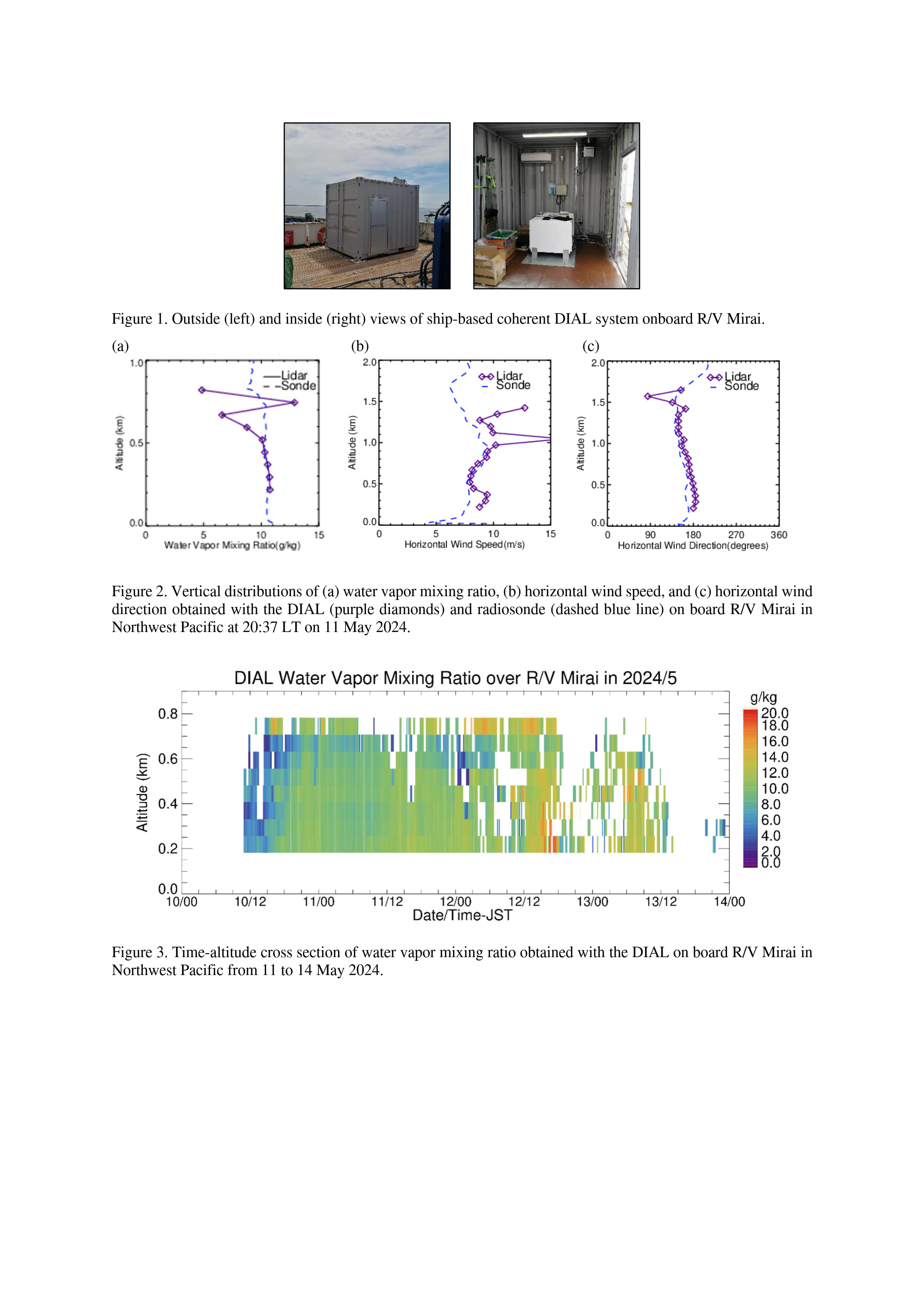
The frequency of occurrence of torrential rainfall that causes extensive damage, has been increasing in Japan for the last fifty years (Japan Meteorological Agency, 2024). Such rainfall mostly occurs when substantial amounts of water vapor flow into the rainfall area over the surrounding ocean, causing deep convections and heavy rainfall over land. For a better understanding of the mechanism and early prediction of heavy rainfall, it is desirable to measure the water vapor and wind distributions over the ocean beforehand. To meet the demands, we have been developing a ship-based coherent differential absorption lidar (DIAL) that simultaneously measures the vertical distributions of water vapor and wind in the lower troposphere. The lidar is based on the prototype version of 1.53-µm coherent DIAL (Imaki et al., 2020a, b). We modified the system by enclosing an air-conditioned container with the outside dimensions of 2.6 m high by 2.4 m wide by 3.0 m long and a glass window on the roof to prevent sea spray and maintain the temperature and humidity for operation (Fig. 1). The total weight is 2.4 t. The lidar transmits laser pulses at wavelengths around 1.53 µm with a pulse energy of 20 µJ and a repetition rate of 32 kHz at a zenith angle of 11.2° in azimuth-angle intervals of 90° every 2 seconds. The backscatter signal from the atmosphere is heterodyne detected by a balanced receiver and converted to an electrical signal. The temporal and vertical resolutions of the measurement are 1 second and 75 m, respectively. For the water vapor measurement, we accumulated the raw data for 10 min to increase the signal-to-noise ratio and reduce the random uncertainty. For the horizontal and vertical wind speed measurement, we use the line-of-sight Doppler velocities in the four azimuthal directions. The measurement ranges are from 0.2 km to 0.8 km for water vapor and 0.2 to 1.7 km for wind.
We conducted the validation experiments onboard the research vessel Mirai in Northwest Pacific from 11 to 16 May and from 21 June to 30 July 2024. During the experiment, the DIAL was operated continuously, and radiosonde observations every 3 to 6 hours were utilized to validate the DIAL measurements. Figure 2 shows the vertical distributions of water vapor mixing ratio, horizontal wind speed and direction obtained with the DIAL and radiosonde at 20:37 Japan Standard Time (JST) on 11 May 2024. The values measured with the two instruments fairly agreed in the lower altitude ranges (below 0.5 km for the water vapor mixing ratio and 1.0–1.4 km for horizontal wind), although the DIAL data showed large variations in the higher range, probably due to the low signal-to-noise ratio. Figure 3 shows the time-altitude cross section of the water vapor mixing ratio obtained with the DIAL from 11 to 14 May 2024. During the period, a front passed over the vessel on 12 May and it rained after 19:30 JST that day. The figure shows that the water vapor mixing ratio increased from 5 g/kg to over 10 g/kg after 13 JST on 10 May with the approach of the front. These data would be useful for studying the vertical structure of moist inflow over the ocean and the mechanism of heavy rainfall formation. We will show the detailed results of the validation experiments in the presentation.

- Indicates paper has been withdrawn from meeting

- Indicates an Award Winner
