
Handout (6.4 MB)
The Pilot Report (PIREP), JMA-Meso Analysis (MANAL), and Collaborative Actions for Renovation of Air Traffic Systems (CARATS) open data were used in this study. PIREP provides data reported by pilots on the position and intensity when encountering turbulence or other conditions. MANAL data covers the area around Japan, divided vertically into 15 layers up to 50 hPa, with a horizontal resolution of 5 km and a temporal resolution of 3 hours. CARATS open data records the position of aircraft flying around Japan approximately every 10 seconds. The analysis period covers May-July 2010-2017. CARATS open data from May 2012 was used. By dividing the number reported in PIREP by the CARATS open data, it is possible to compare the ease of encounter, ignoring bias due to the number of cruises. We categorized MWT and CIT from PIREP and other cases as CAT. CAT and CIT of moderate intensity occurring above 400 hPa were focused on. A Meiyu-Baiu front was extracted using MANAL, and the distance to the point of reported turbulence was calculated for each case. Turbulence indices and meteorological quantities at the point of reported were calculated for each case, and histograms of probability density functions were plotted for each variable by distance from the Meiyu-Baiu front. A similar analysis was conducted for winter (December, January, and February) CAT cases and compared.
Figure shows the horizontal distribution of non-MWT for the analysis period reported above 400 hPa. The color of the dots indicates the distance from a Meiyu-Baiu front, with red indicating cases encountered in the north and blue in the south. The blue histograms on the right and at the top of the panel indicate the number frequency of turbulence encounters divided by the number of flights by latitude and longitude, respectively. The green histogram shows the position of a Meiyu-Baiu front. The width of each bin is 2°. In the period analyzed, turbulence were most likely to be encountered in the area between 142°E and 146°E and between 36°N and 40°N. The number of encounters was higher north of a Meiyu-Baiu front than south. The number per distance was highest in the north, 300 km to 400 km from a Meiyu-Baiu front, decreasing as the distance increased. In the south, encounters were more common in areas closer to a Meiyu-Baiu front, especially in the 200 km to 300 km area. The present study focused on cases north of a Meiyu-Baiu front. The probability density function of the vertical wind shear at the point of occurrence showed a peak at weaker values within 300 km of a Meiyu-Baiu front compared to winter. Beyond 300 km, the distribution was similar to that in winter. A same trend was observed for the horizontal gradient of temperature, deformation multiplied by wind speed, and Ellrod 1. Deformation was similar to winter within 300 km, but stronger than winter beyond 300 km. These results suggest that the factors contributing to turbulence outbreaks differ between areas within 300 km of a Meiyu-Baiu front and those farther away. Jet streams often contribute to CAT in winter in Japan. It is therefore suggested that the jet stream frequently contributes in areas more than 300 km from a Meiyu-Baiu front.
The poster presentation will further discuss the analysis results of the average environmental field around the turbulence source point at different distances, as well as the reasons why the probability density function differs between regions within 300 km of a Meiyu-Baiu front and farther away from it and the areas where a Meiyu-Baiu front is expected to contribute.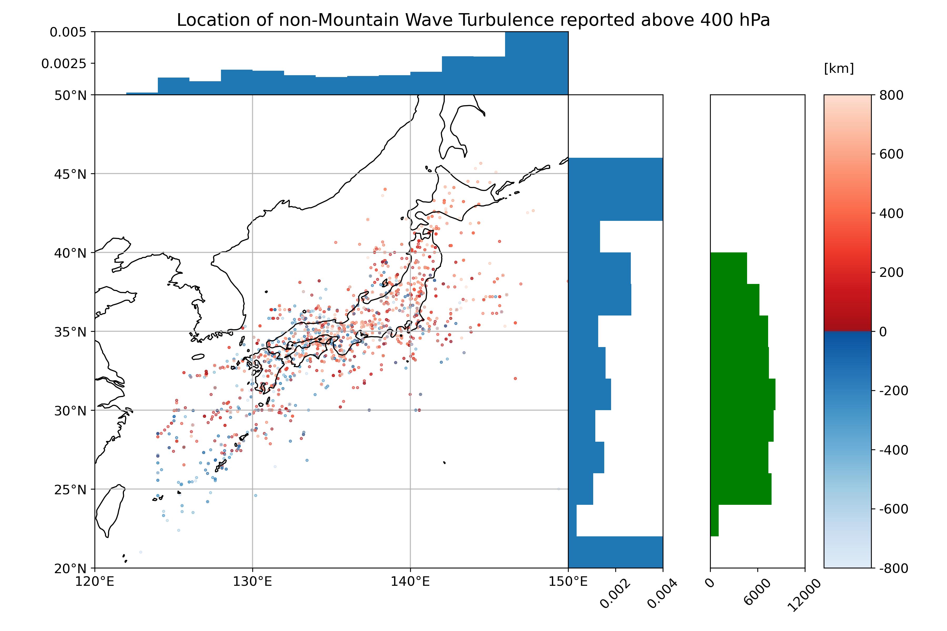
 - Indicates paper has been withdrawn from meeting
 - Indicates an Award Winner