
During the studied event, which is analyzed using available observations and numerical simulations, severe storms were triggered in the Alps, moved eastward, rapidly intensified in the foothills, and generated damaging hailstorms in the plains. The first storm crossed the FVG region around 1900 UTC and produced 9 cm hailstones in the village of Mortegliano, causing extensive damage to cars and buildings (approximately € 170 M in economic damages were estimated). Two hours later, a second supercell generated the record-breaking 19 cm hailstone in the municipality of Azzano Decimo, and giant hailstones fell along a remarkable 80 km path.
Radar images showed that both supercells were characterized by a 5 km wide Bounded Weak Echo Region, indicating the presence of very wide updrafts. A high-Theta_e tongue over the Adriatic Sea was lifted by a southerly flow above the cold pool generated by the thunderstorm outflow associated with the first supercell. This resulted in the most unstable layer being located at 1-2 km above mean sea level in the area affected by the record-breaking hailstorm. The vertical profile was characterized by moderate values of potential instability (about 1200 J/kg) and an intense southwesterly flow in the mid-troposphere. Additionally, there was anomalously high water vapor transport in the 2-5 km above mean sea level layer. Consequently, a very high instability does not appear to be necessary for the occurrence of giant hailstorms in the region. On the other hand, the intense moist flow in the mid-troposphere was likely much more important, as it led to strong bulk wind shear, wide updrafts, and intense water vapor transport, all of which are key features for large hail generation.
This hypothesis is supported by a statistical analysis performed for the 2018-2023 period in Northeastern Italy using hail reports and environmental parameters derived from observed soundings in Udine. The results show that hail size has a much lower linear correlation with potential instability (R of about 0.3) than with kinematic parameters of the mid-troposphere and water vapor transport (R of about 0.5-0.6). Furthermore, it is found that thermodynamic parameters are more effective in predicting the occurrence of hail or large hail (>2 cm), while mid-troposphere kinematic parameters are better predictors for discriminating very large (>5 cm) and giant (>8 cm) hail events. In conclusion, our findings suggest that truly distinguishes large hail and giant hail environments are the dynamic characteristics of the troposphere, particularly the intensity of mid-tropospheric flow and moisture transport.
Figure 1a caption: Vertical Maximum Intensity (VMI) measured by the Fossalon di Grado (location shown as black dot) radar of the Civil Protection of the Friuli Venezia Giulia region at 1905 UTC on July 24, 2023; the lateral projections of VMI are also shown. The locations of Azzano Decimo, Mortegliano, and of the Udine sounding (black square) are also reported.
Figure 1b caption: Vertical profile of water vapor transport (defined as the product of horizontal wind speed and mixing ratio) measured in Udine (WMO code 16045, location shown with a black square in Figure 1a) at 1200 UTC (cyan solid line) and 1800 UTC (green solid line) on July 24, 2023, and at 0000 UTC on July 25, 2023 (purple line). The black line is the mean profile for the months of June, July, and August during the 2018-2023 period, while the grey shading highlights the area between the 10th and 90th percentiles during the same period.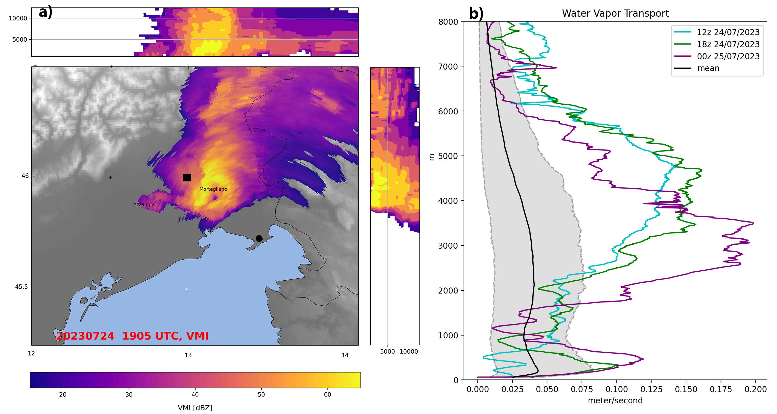
 - Indicates paper has been withdrawn from meeting
 - Indicates an Award Winner