
The World Health Organization estimates that climate change will cause an additional 48,000 deaths per year resulting from diarrheal disease between 2030 and 2050. The literature on this topic suggests seasonal trends in diarrheal disease outbreaks, specifically between periods of high rainfall and increased risk of the disease; although some studies report no significant correlation with high rainfall alone. Additional work has found that dry periods antecedent to heavy rainfalls have a significant correlation to DD outbreaks, however other factors may also be important. These include the geography and land use and land cover. Studies have found significant differences between DD prevalence in urban versus rural areas where factors such as population density, sanitation practices, and safe drinking water availability can vary widely. Some studies find land cover change, including forest loss to be associated with increased DD incidence. Forests provide water filtration services and influence soil erosion which may help to dilute pollutants. The topography can also influence pathogen exposure levels. Lower-lying regions, like much of Bangladesh, can be more at risk for extreme flooding from even minor rainfall leading to reduced security and stability of heath infrastructure. Flooding events, which are more persistent with climate change, are shown to increase pathogen exposure and water contamination levels, jeopardizing human health and the resiliency of sanitation infrastructure.
In order to craft effective prevention and treatment programs, sufficient data on the social, technical, political, and environmental systems must be attained and analyzed to determine direct drivers of DD occurrence. While standard epidemiological approaches remain useful, new computational techniques that can identify relationships embedded in large complex data sets are needed and machine learning models, such as random forest classifiers, are well suited to this challenge. This study applies Random Forest machine learning techniques to environmental, health, socio-economic, and geospatial data to understand and identify their association with DD incidence in the country of Bangladesh to demonstrate the feasibility and utility of identifying variability in disease drivers across scales using these techniques.
We use data collected by the Demographic and Health Surveys Program (DHS) operated by the United States Agency for International Development. The DHS survey data used in this study consists of N = 21,779 households belonging to N = 600 villages. In addition to DHS Program survey responses, geographic (e.g. forest cover loss) and antecedent weather variables (e.g. slope, temperature, precipitation, population density) were computed for each village. Forest cover was calculated from the Hansen Global Forest Change dataset (Hansen et al. 2013), while the global Climate Hazards Group InfraRed Precipitation with Station (CHIRPS) dataset was used for precipitation and the Climate Hazards Group InfraRed Temperature with Station (CHIRTS) monthly dataset for temperature. The random forest (RF) machine learning algorithm was used to determine which factors had the highest predictive power in determining disease burden at the household and village scales using Shapely values to understand feature influence on the model output. At the household scale, HHs were coded as having a child experience DD in the previous two weeks. At the village scale, HH were coded as belonging to a village with “high” DD prevalence or a “low” DD prevalence with villages having 3% or more of households experiencing DD considered “high” prevalence which resulted in a 20%-80% split of the data into the “low” and “high” subsets, respectively. Independent factors were then used to predict likelihood of HH belonging to the high or low DD prevalence group. Figure 1 summarizes the data used at the household and village level as well as the results of the random forest classification.
At the household level (Figure 1a-d), results indicate that the age of the child and stunting status are the top two predictors. The ten following features (Fig 1c, d) have a similar importance and include geographic and weather-related factors such as previous and current month precipitation and temperature, distances to large water bodies and roadways, average elevation and slope, population density, and age of head of household. At the village level (Figure 1e-h), similar top predictors (geographic and weather features) are observed (Fig 1g,h); however, both Stunting and Age of Child do not appear to be important features in determining HH membership in the high or low DD prevalence groups. Geographic features rank high in importance including the top three features: distance to large water bodies (oceans or lakes), average slope, and average elevation. These are followed closely by weather features of current and previous month’s precipitation and temperature, then distance to road and climate season. A considerable decrease in importance occurs at both scales (HH and village) for factors including Education, Gender, Improved Sanitation, Climate Season, Breastfeed, Wealth, Birth Order, Sex of Head of household, and Forest Loss Hotspot.
Our findings validate previous findings suggesting DD occurrence strongly associated with climatological factors and individual characteristics but at different scales. We did not find proximate forest loss to be an important factor in disease occurrence. These results suggest the importance of including both household level and geographic scales in the design and targeting of public health interventions. 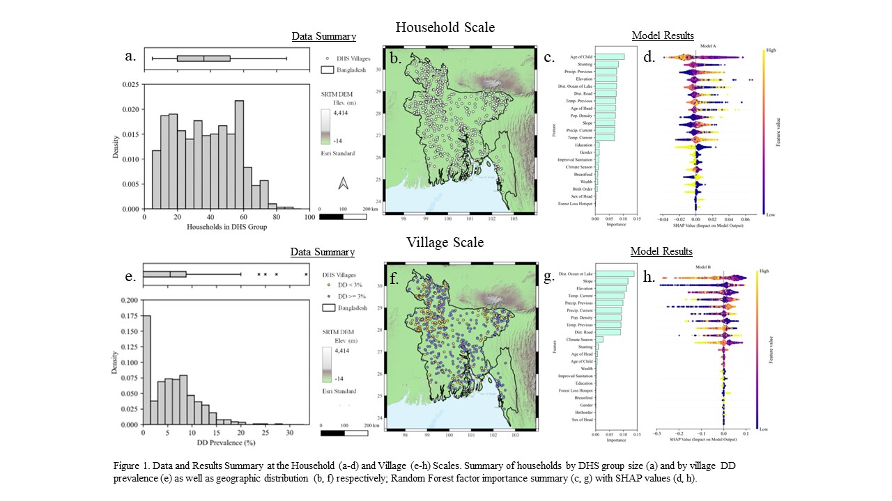
 - Indicates paper has been withdrawn from meeting
 - Indicates an Award Winner