
Wednesday, 15 January 2025: 11:30 AM
339 (New Orleans Ernest N. Morial Convention Center)
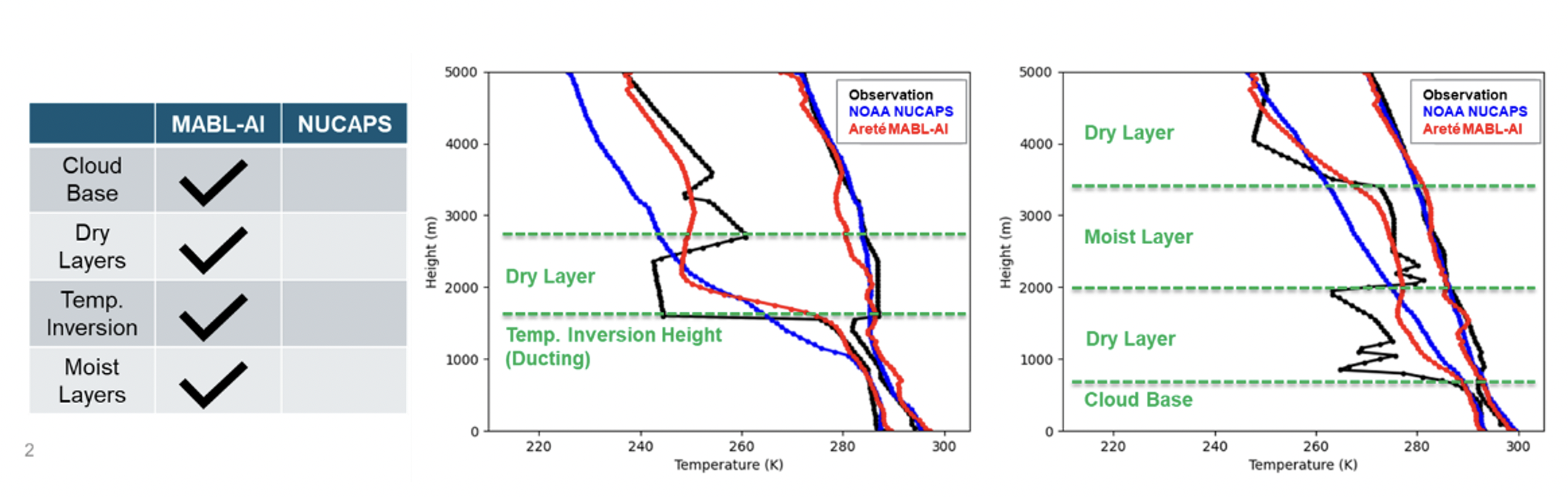
Areté, in collaboration with the University of Alabama in Huntsville (UAH), has developed an artificial intelligence (AI) data fusion system to improve the characterization of the atmospheric boundary layer. The MABL-AI framework is a deep learning approach to data fusion for deriving high-resolution thermodynamic profiles of the lowest 5 km of the Marine Atmospheric Boundary Layer (MABL), while capability is increasing to form profiles to 12 km altitude. Supported by the Office of Naval Research under the Small Business Technology Transfer (STTR) program, MABL-AI uses available single-source satellite retrievals, other complementary data sources, and high-quality radiosonde data as truth, to upscale satellite-retrieved temperature and moisture profiles to a vertical resolution of 50 m, capable of capturing important MABL features, including inversions, elevated dry and moist layers, and the tropopause. MABL-AI profiles reduce thermodynamic sounding errors in global maritime environments by 60% compared to the NOAA Unique Combined Atmospheric Processing System (NUCAPS) and better captures inversion characteristics. The MABL-AI system is currently being expanded globally and integrated with the Geolocated Information Processing System (GeoIPS) to support data assimilation and operational forecasting applications. The conference presentation will focus on the progress to date to create a global MABL-AI sounding dataset, available nominally at a spatial resolution of ~0.25° x ~0.25° latitude/longitude and at a time resolution of at least twice daily. Beyond the vertical soundings of temperature and moisture, so-called 2D feature maps will also be demonstrated, which will show estimates of the MABL inversion level, elevated dry and moist (or cloud) layers, and tropopause altitudes. The strength of the MABL-AI dataset is that it produces soundings of higher accuracy than those derived from multi- and hyper-spectral infrared and microwave satellite imagery, and that such soundings form an independent new dataset that can be used to initialize numerical weather prediction models. As such, plans include evaluating the MABL-AI soundings in hybrid 4D-Var data assimilation approaches. Lastly, the MABL-AI soundings can potentially offer product developers and mission planners (e.g., NASA PBL Mission) a database that characterizes the planetary boundary layer globally, as it provides sounding information in the absence of radiosondes.
 - Indicates paper has been withdrawn from meeting
 - Indicates an Award Winner