
The velocity estimates are based on the assumption that tracers move along with the wind. However, in a debris cloud near a tornado vortex, the increased mass of larger scatterers leads to an additional centrifugal-acceleration-added motion to that of the actual wind. Massive scatterers are typically centrifuged radially outward from the vortex. Therefore, to study the wind field, we must separate and remove the contaminating effects of debris. For this problem, we can use polarimetric spectral densities (PSDs). Since debris scatterers are usually irregularly shaped, there is not much correlation between the backscattered horizontally and vertically polarized radar signals. With PSDs, we can examine the Doppler spectrum, which can be used to separate contributions from debris and hydrometeors, allowing us to filter out the effects of debris. The generation of PSDs requires the collection of raw I/Q data, which are the unprocessed complex signals from the radar transceiver.
For the first time, on 11 May 2023, RaXPol was able to successfully collect I/Q data through a tornadic wind field in an EF-1 southwest of Norman, Oklahoma. Due to an error in the scanning software, only a few scans were at a low-enough elevation angle to contain debris. However, on 23 May 2024, after resolving issues with the software, an I/Q dataset of a long-lived EF-2 near East Duke, Oklahoma was collected, at sufficiently low elevation angles, to observe the debris cloud for an extended period of time. It is thought that this dataset shows the contribution of the centrifuging of debris in the low-level wind field. A sample of processed radar data and PSDs are attached in the figure (not corrected for aliasing). With the given folded PSD, we are also able to see that the maximum radial wind speed for this scan is around 58 m/s, around 10-15 m/s higher than the mean value depicted in the velocity PPI view. Radial wind speeds in excess of 90 m/s were also observed earlier in the lifecycle of the tornado. In this presentation, we aim to interpret these spectra to demonstrate the presence of debris centrifuging and interpret the tornadic wind field along with other properties of the debris cloud.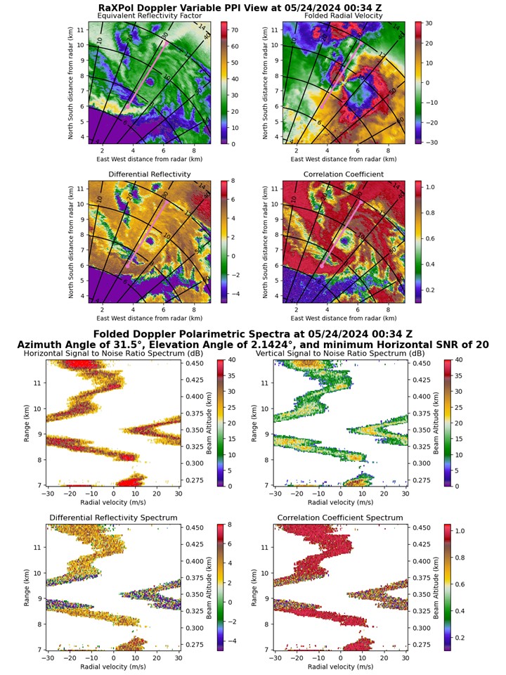
 - Indicates paper has been withdrawn from meeting
 - Indicates an Award Winner