Thursday, 16 January 2025: 2:45 PM
222 (New Orleans Ernest N. Morial Convention Center)
Zhu (Judy) Yao, The Pennsylvania State Univ., University Park, PA; The Pennsylvania State Univ., University Park, PA; and Y. Zhang, PhD, X. Chen, and E. E. Clothiaux
Satellite passive radiances, or brightness temperatures (Tbs) converted from radiances, are sensitive to moisture, cloud, and precipitation. In cloudy and/or precipitating regions of tropical cyclones (TCs), such as the eyewall and spiral rainbands, infrared (IR) Tbs from geostationary satellites inform on cloud locations and cloud-top heights. Microwave (MW) Tbs from low-Earth-orbit satellites contain information on hydrometeor phase, amount, and location below cloud tops. Effective assimilation of satellite all-sky Tbs is thus vital to improving TC analyses and forecasts. This study examines four TCs from the 2017 Atlantic Hurricane Season using the Weather Research and Forecasting model coupled with an ensemble Kalman Filter (WRF-EnKF) data assimilation system, incorporating the Community Radiative Transfer Model (CRTM) to calculate model Tbs. Analyses and forecasts were statistically evaluated through three types of experiments based on assimilation of: conventional observations (CONV), conventional and GOES-16 IR observations (IR), and conventional, GOES-16 IR, and GPM-constellation MW observations (IR+MW). Additionally, the impacts of microphysics parameterization (MP) scheme on assimilation of satellite all-sky Tbs was assessed by two types of experiments: the WSM6 set of experiments employed the WRF single-moment-6-class (WSM6) scheme and the THO set used the Thompson et al. (2008) hybrid scheme with double-moment cloud ice and rain.
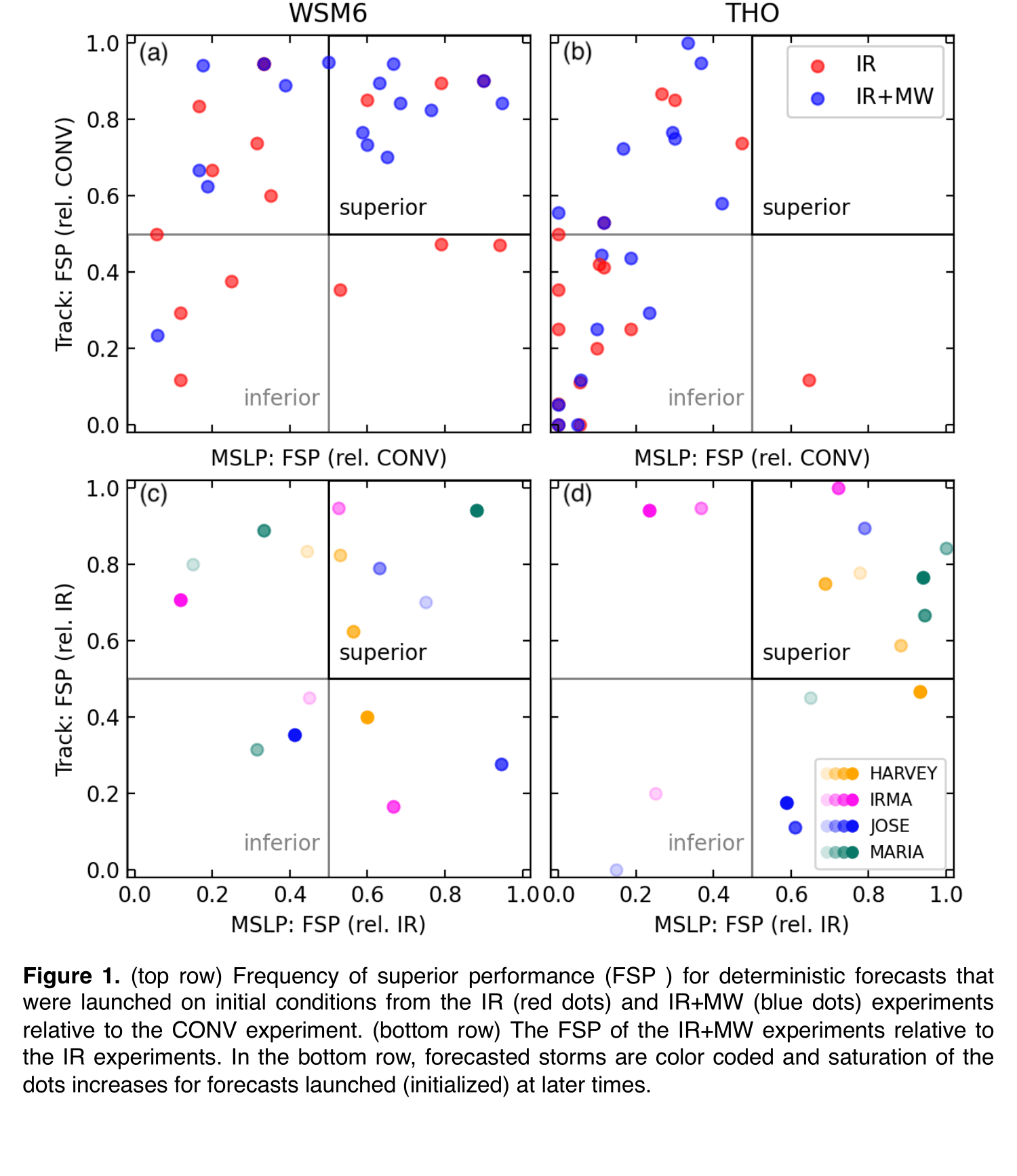
The impacts of assimilation of satellite all-sky Tbs on TC analysis and prediction is significant, as is the choice of MP scheme. TC analyses and forecasts show little difference between the CONV_WSM6 and CONV_THO experiments. However, the analyzed and forecasted TCs in the WSM6 experiments are notably stronger than those in the THO experiments for both IR and IR+MW experiments. This discrepancy is closely linked to differences in cloud-top heights produced by the MP schemes, and the impact of these differences on the calculated IR radiances. Additional assimilation of MW Tbs, which are not nearly as sensitive to cloud-top height changes, improves IR+MW forecast performance for both track and intensity compared to the IR experiments (Fig. 1). This result indicates that the MW TBs are providing useful information on hydrometeors throughout vertical columns thereby helping to correct deleterious impacts of cloud-top height errors on forecast performance.

- Indicates paper has been withdrawn from meeting

- Indicates an Award Winner
