
Second, I’ll describe FLUJOS (Flood Justice Utilizing Satellite Observations), co-produced with lawyers from Texas Rio Grande Legal Aid and five community based organizations. Organizations aim to use inundation maps to seek flood justice for informal urban residents via i) focusing where to clear titles so flooded residents can access FEMA funds, ii) impact litigation (eg. suing FEMA for discrimination), iii) holding local officials and the EPA accountable. We are co-producing a flood database, validated, and trained on over 100 resident flood experiences. I will show a draft of the tool we’ve developed with Development Seed, mapping 15 flood events across Hidalgo and Cameron counties (Texas) with Sentinel-1 and Planetscope data.
Third, I’ll show efforts from a new NSF CAREER grant to address flood justice and equity impacts of adaptation and urban expansion with satellite observations across the US. Building in the floodplain plays a larger role in increasing exposure than a changing climate. To expand urban development, preserve property values, or avoid paying for flood insurance, real estate developers in the US may request to remove properties from the Federal Emergency Management Agency (FEMA) regulatory floodplain by building flood mitigation infrastructure. Satellite data could help assess if this infrastructure is reducing inundation, and if it could be draining floodwaters to underserved communities downstream. his project will advance knowledge by generating observed flood data to measure if and where flood mitigation infrastructure changes flooding who is affected. The project will build capacity for environmental justice organizations to use satellite-based flood maps to challenge changes to FEMA flood maps and advocate for adaptation funding for their communities. This project will contribute to building more just flood adaptation, quantify past flood mitigation policies that increase flood exposure to underserved communities, and address long-standing injustice.
As floods impact more people and property, policies must evolve to address growing risk and prioritize protection for the most vulnerable. Current regulatory floodplain maps from FEMA underrepresent flood risk, which most research assumes is due to failure to produce or update maps, or incorporate different flood causes. Yet, the “undermapping” of flood risk could also be due to reductions in regulatory floodplains from real estate developers who can demonstrate they decreased the floodplain with mitigation infrastructure though the Letters of Map Revision (LOMR) policy. Is flood mitigation infrastructure effective at reducing flooding in future events? Do observations of flood events show that these redrawn floodplain maps are accurate? This project will analyze where FEMA flood maps have been reduced due to LOMR policies and build a spatial database of flood events from multiple satellite observations from 2001-2023 using machine learning to evaluate these questions. In addition to protecting the property for which it was built, flood mitigation infrastructure could displace floodwater to underserved communities. To what extent is flood mitigation infrastructure responsible for increasing inequitable flood exposure? This question is answered by combining census data together with satellite observations and statistical models to assess if the burden of flood risk shifts to different demographics (e.g from wealthier and Whiter to lower-income or communities of color). The project integrates students and staff from environmental justice organizations to be jointly trained to co-produce satellite-based tools for flood mapping to challenge flood injustice in the US. The research will democratize heretofore unavailable access to high quality flood observation data using machine learning and high-resolution satellites to populations with no previous training in either.
Finally, I’ll end with a call to join our new NSF Research Coordination Network (RCN) to Catalyze Flood Justice in the US. Our proposed Research Coordination Network (RCN) aims to address flood injustice by creating a transdisciplinary network of researchers, policymakers, and community-based organizations. The network will synthesize data and insights, catalyze action, and advance knowledge on how flood injustice is shaped by interactions between social, natural, and engineered systems. The RCN will be organized around two research themes: mechanisms of urban development and climate change that shape flood risk futures, and broadening participation and co-production of place-based research to address flood justice. Key activities include hosting workshops that leverage the thematic expertise of steering committee members, fostering collaboration and knowledge sharing. The network is led by Dr. Aaron Flores from Arizona State University, together with myself, Toni Sebastian from University of North Carolina, Eric Tate from Princeton, and Marccus Hendricks from University of Maryland.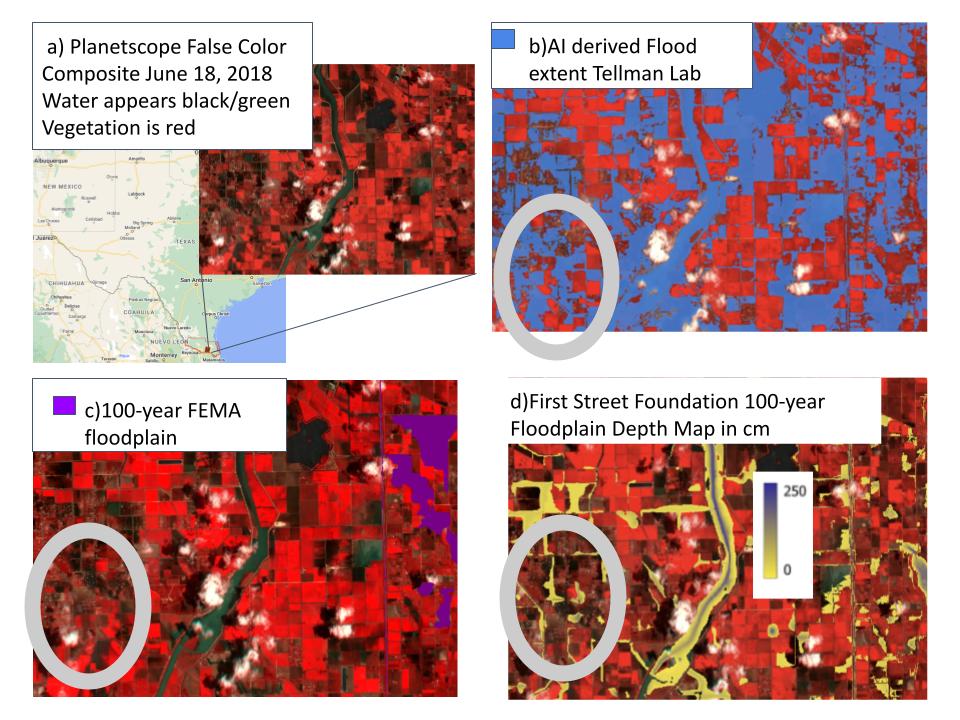
 - Indicates paper has been withdrawn from meeting
 - Indicates an Award Winner