
We explored how synoptic-scale weather systems impact aerosol mixing processes within the daytime ABL over a site located in a dryland. In particular, we seek to address the following questions: (1) How far did the smoke and aerosols from the Panhandle wildfire travel? (2) How did the prevailing synoptic conditions help determine the transport pathways and altitudes of the “unhealthy” smoke plume emitted from the fire? (3) How atypical was the underlying climate of Feb 2024 in comparison to the “normal” near-surface climate conditions of the region? (4) How does the combination of both dryline and cold front passages help determine the mixing and transport of aerosols over this region? The continuous scanning Doppler lidar measurements from the Reese Center (> 250 km south of the Panhandle) in Lubbock, Texas, was used to study both the plume near the ground and aloft as the lidar registered horizontally transported components of the wildfire plume to an altitude of 1500 m above ground level. During the wildfire, the Panhandle region witnessed (1) a well-built dryline sweeping through the experimental region of Lubbock bringing extremely dry air from the west during the late afternoon; (2) anomalously warm conditions during the day with sustained high westerly wind and gusts (> 40 knots) and blowing dust for more than 6 hours; (3) a strong late evening cold front yielding a significant temperature drop of 15 oC, and (4) wildfire smoke plumes arriving in the air above Lubbock in the late evening (27 Feb 2024) affecting the air quality and visibility, and prompting a health hazardous condition overnight and the next day (28 Feb 2024).
The combined measurements collected by the West Texas Mesonet, scanning Doppler lidar, and in-situ aerosol sensors provided a comprehensive overview of the vertical and horizontal transport of smoke plumes over Lubbock during the entire event. The results obtained from these measurements provided strong evidence of the wildfire plumes that were transported from the Panhandle to Lubbock, and which also reached further downstream towards southern portion of West Texas. The unprecedented observations collected during the wildfire event could be used for validating aerosol transport in air quality models and further development of new concepts for air quality forecast models. Additionally, this work will also help raise awareness for the need to explore the impact of synoptic-scale events on aerosol transport over drylands as a critical element of resolving the role of aerosols in the rapidly warming climate of the 21st century.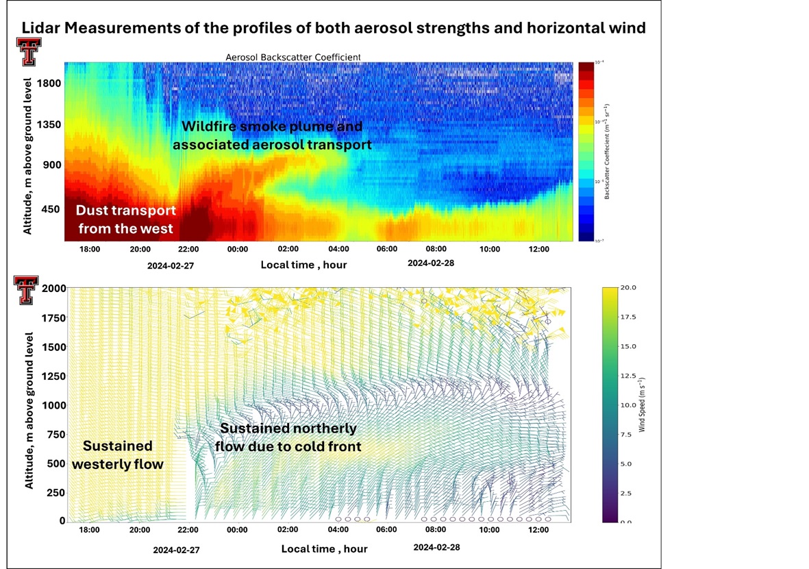
 - Indicates paper has been withdrawn from meeting
 - Indicates an Award Winner