
Fixed buoys, Unmanned Underwater Vehicles (UUVs), and other technologies provide some subsurface data in the coastal zone, but their expense and overhead make it impossible to deploy them in sufficient quantity to more fully characterize the coastal ocean. Fortunately, one of the sectors that is most impacted by the lack of data - commercial fishing - offers an opportunity to close this sensing gap. Over the last 10+ years, the Fishing Vessel Observation Network (FVON), an international consortium of oceanography organizations, has fielded and continued to refine a suite of ocean monitoring instruments that can be attached to commercial fishing gear, providing a vertical profile of the water column for a fraction of the cost of traditional dedicated oceanographic platforms and sensors.
Data quality from these ruggedized sensors has been verified in multiple field tests, and the rapid advance of commercial satellite communications capabilities like Starlink have been making it faster and even less expensive to get the data to shore, often in real time. All the FVON units have temperature and pressure sensors, and additional sensors like salinity, dissolved oxygen, and turbidity have been deployed in limited numbers as prototypes. To date, the approximately dozen partners in FVON have deployed sensors on over 600 vessels worldwide. U.S.-based Ocean Data Network (ODN) is the only commercial company operating in FVON, with over 150 vessels instrumented in the U.S. and around the world.
Beyond fisheries, data from these subsurface profiles can improve understanding of and reaction to marine heat waves, coral bleaching events, Harmful Algal Blooms, hurricane intensification, severe weather, military sensor and weapon performance, offshore renewable energy, and more. A recent 2024 analysis by Kerry et al1 of data from the most mature fishing vessel network, which includes over 200 vessels arrayed around New Zealand, indicated that the temperature data from the vessels led to a ~24% improvement in the model forecast of bottom water temperature, while an earlier 2016 study by Li et al2 correlated North Atlantic surface salinity to downstream rainfall in Africa. Beyond such physics-based modeling, emerging Artificial Intelligence/Machine Learning (AI/ML) techniques offer the opportunity to use ocean temperature and salinity as predictors of a wide spectrum of weather phenomena at varying time scales.
To date, most fishing-vessel based installations have been executed at a project-level scale, with 10-20 vessels covering a sub-region of 100-400 km in extent. While data of this scale is useful locally, a more comprehensive deployment to fully blanket a basin's coastal zone will undoubtedly allow a fuller characterization of the coastal waters and thus yield improved results.
ODN is in the planning stage of just such a deployment, scoping out and seeking backing for a large-scale deployment on 200-250 vessels and providing coverage from the Gulf of Mexico up the U.S. East Coast and across the North Atlantic to the North Sea - dubbed the North Atlantic Arc. It has targeted an average spacing of 100km along this extended arc, which would approximately double the Argo spatial density and provide an unprecedented coastal data set to feed real time monitoring and both physical and AI/ML modeling.
The proposed talk would discuss the work to date on fishing vessel-based ocean observing, lay out the motivation and design considerations for ODN's North Atlantic Arc, and provide an update on network deployment.
1Kerry, C., Roughan, M., & de Souza, J. M. (2024). Assessing the impact of subsurface temperature observations from fishing vessels on temperature and heat content estimates in shelf seas: a New Zealand case study using Observing System Simulation Experiments. Frontiers in Marine Science, Vol 11. https://doi.org/10.3389/fmars.2024.1358193.
2Li, L., Schmitt, R., Ummenhofer C., & Kamauskas, K. (2016). North Atlantic salinity as a predictor of Sahel rainfall. Science Advances, Vol 2, No. 5. https://www.science.org/doi/10.1126/sciadv.1501588.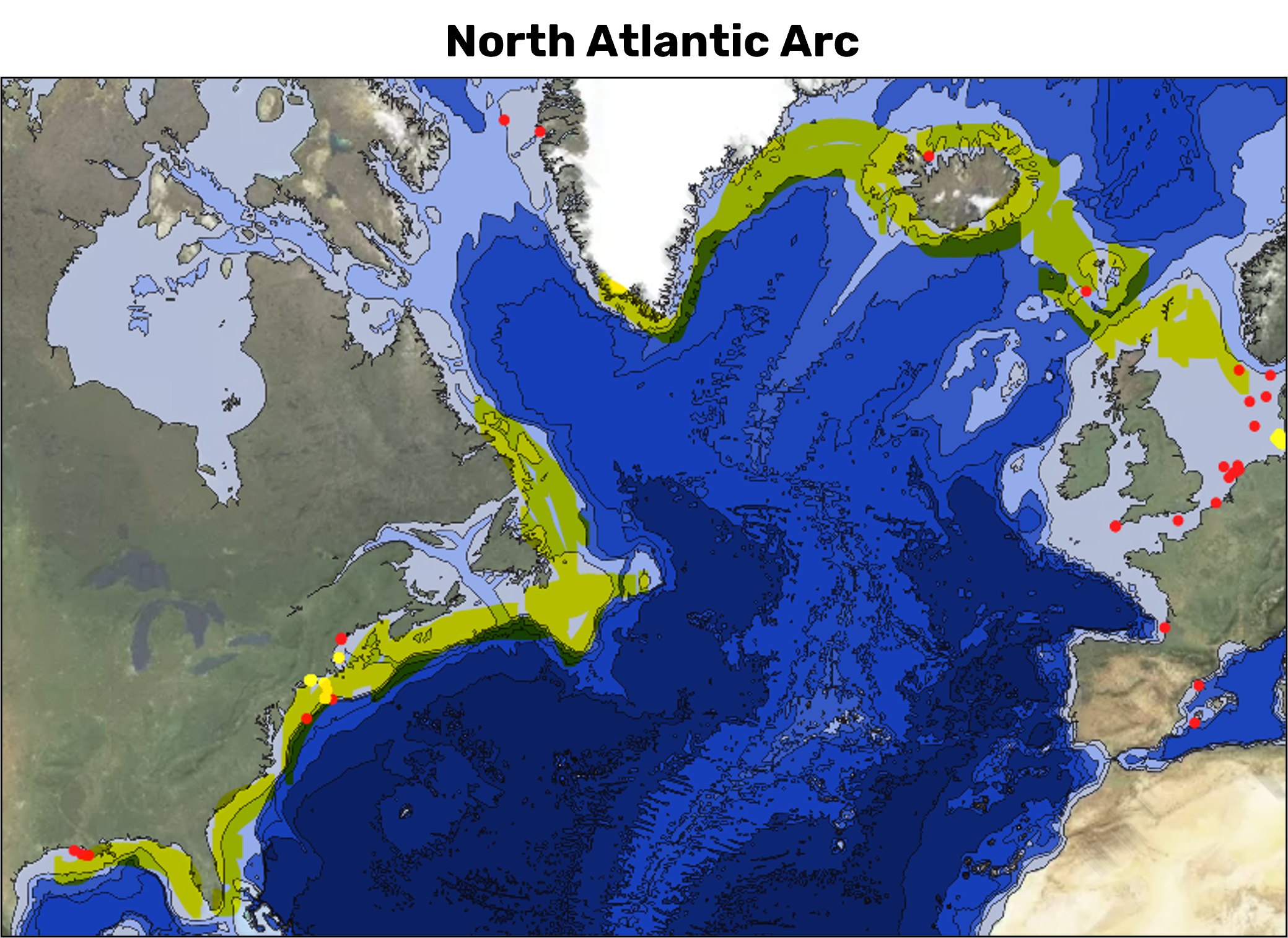
 - Indicates paper has been withdrawn from meeting
 - Indicates an Award Winner