
The DPR observations over Japan were verified through the use of XRAIN ground-based radar and JMA rain gauges. XRAIN is comprised of X-band and C-band radars, and it measures the precipitation rate at the altitude closest to the ground surface with a temporal resolution of 1 minute and a spatial resolution of 250 meters. These data were averaged over a 1 kilometer grid, and the value of the 1 kilometer grid closest to the center of the DPR observation footprint was utilized for validation. The time difference corresponding to the difference in observed altitude between DPR and XRAIN was set to 0. Due to the decreased accuracy of XRAIN farther away from the radar site, the validation area was limited to land. The DPR algorithm comprises the KuPR algorithm, which utilizes only KuPR, the KaPR algorithm, which utilizes only KaPR, and the dual-frequency algorithm, which employs both. Comparatively, the KuPR algorithm exhibits the highest correlation coefficient with XRAIN, while the KaPR algorithm demonstrates the weakest correlation. The KaPR algorithm displays a notable underestimation when XRAIN exceeds 10 mm/h. For incidence angles at 3 degrees or below, the correlation coefficients for all algorithms were low. This may be attributed to the significant variation in the surface backscatter cross-section utilized for the surface reference method, which diminishes the accuracy of path integrated attenuation estimation. When the surface reference technique was not employed for precipitation rate estimation, and instead, a condition was implemented to minimize the variability of the vertical precipitation rate profile, the estimation improved for small incidence angles. However, when the incidence angle was greater than 9 degrees, the error was larger than when the surface reference technique was utilized. Therefore, it is essential to alter the use of the surface reference technique based on the angle of incidence.
Validation using XRAIN has not been successful in distinguishing errors in XRAIN from those in DPR. When XRAIN was contrasted with observations from a disdrometer, it was observed that XRAIN overestimated when the disdrometer made observations of 10 mm/h or less. Therefore, we propose correcting XRAIN with rain gauges. While XRAIN data has a resolution of 1 minute, calculating the 1-minute precipitation rate from rain gauges is inaccurate. The rain gauge utilized by the Japan Meteorological Agency measures in units of 0.5 mm, and if the number of tipping is multiplied by 0.5 mm and divided by the time (1 minute), the result is a value for each 30 mm/h of precipitation rate. Thus, the interpolation method developed by the authors was utilized. This method statistically estimates the time of occurrence of tipping and assumes that the precipitation intensity between two consecutive occurrences of tipping remains constant. Given that XRAIN is applicable in this context, it is assumed that the time variation of precipitation rate between tipping events is proportional to the time variation of precipitation rate in XRAIN, and 0.5 mm of precipitation is allocated between the two tipping events. A correction factor for precipitation intensity at XRAIN was subsequently obtained, which was spatially interpolated and utilized to correct XRAIN in the absence of rain gauges. For the period 2022-2023, the validation results of the KuPR algorithm for the Kyushu region are shown in Figure.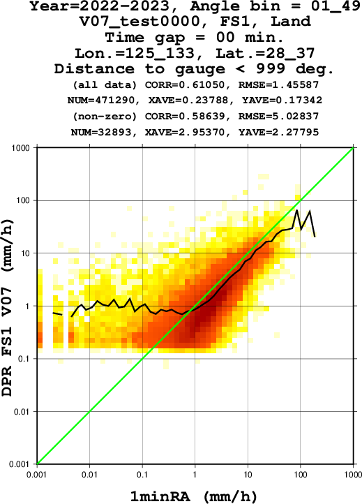
 - Indicates paper has been withdrawn from meeting
 - Indicates an Award Winner