
Handout (458.1 kB)
The Urban Heat Island Effect (UHIE) refers to the phenomenon where urban areas experience higher temperatures than their rural surroundings. This effect results from the replacement of vegetation with materials that have low reflectivity and high heat retention. While previous studies have predominantly focused on UHIE in flat terrains and surface temperatures, there is limited research on its impact in elevated terrains or its correlation with the effective air temperature (TAIR) that humans experience in daily life in association to the UHIE. This study aims to investigate height-to-width ratios of greenspaces and buildings, along with elevation, and examine their correlation with TAIR and heat related health risks experienced by people.
- METHODOLOGY
We conducted environmental data along a 2.2-mile transect in the Historic Old Town area in urban Albuquerque, NM. The transect begins and ends at the entrance of Old Town. (Figure 1). Data collection took place twice a week—Wednesdays and Sundays—at three times per/day: 8:00-9:00 AM, 2:00-3:00 PM, and 7:00-8:00 PM. Continuous TAIR measurements were recorded using an Airbeam-3 sensor. Since the Airbeam TAIR data reflects the internal temperature within the sensor’s radiation shielded housing (internal temperature) and not the true TAIR, a Kestrel-3000 environmental sensor was used for calibration purposes. The transect was divided into 12-stations located 5-minutes walking-distance apart, where Kestrel TAIR data was collected. The final corrected TAIR values were obtained utilizing the Kestrel and Airbeam data in combination with a mathematical model employing a second-order polynomial curve-fitting protocol. Elevation data for each station was obtained from google earth. Pearson’s correlation coefficient is used to analyze the correlation between TAIR, elevation, green H/W ratios, and building H/W ratios.
- RESULTS & DISCUSSION
This study was designed to answer three research questions (RQ):
(RQ1): How does the H/W ratio of green spaces and buildings affect air temperature?
(RQ2). How does elevation affect air temperature?
(RQ3). Does the urban environment influence heat-related health risks in humans?
Table 1 and Figures 2 and 3 address RQ #1. The data shows a poor correlation between TAIR and green H/W ratios in the afternoon and evening but a positive correlation in the morning. Building H/W ratios also show weak correlations with TAIR, with a fair-negative correlation in the evening. These results likely stem from insufficient consideration of proximity. Cardilini et al. (2023) found that close green spaces (within 100m) positively impact health, while those at greater distances have lesser effects. Similarly, this study found lower TAIR and reduced heat disorder likelihood closer to green spaces (e.g., Station 4 is ~20-40 ft in proximity to green space) compared to those further away (e.g., Station 5 is ~30-50ft in proximity to green space). Building H/W ratios had minimal impact due to the distances between buildings and stations. The vast majority of the buildings were found ~70-90 ft away from each station, with five stations being outside of the 100 ft radius.
Table 1 and Figure 4 address RQ #2. Table 1 defines the correlation between TAIR and elevation quantitatively, while figure 4 serves as a visual-representation. Figure 4 suggests the average afternoon TAIR has the highest positive correlation with elevation, the average evening air temperature has a negative correlation with elevation, and the average morning temperature is independent of elevation. Figure 2 suggests that elevation has a fair-positive correlation and a fair-negative correlation between evening and afternoon air temperatures respectively, as well as a poor correlation with morning air temperatures. The weak correlation between elevation and morning air temperature is likely due to the bias in time of data collection, as the sun’s rising causes the air temperature to steadily increase; which may also explain the fair-positive correlation between average morning TAIR and green H/W ratios. While temperature typically decreases with significant elevation changes (Tang et al., 2022), urban microclimates show a positive correlation between elevation and afternoon TAIR due to increased radiation, and a fair-negative correlation in the evening as sunlight diminishes.
Figures 5-7 address RQ #3. The Heat Index (Figures 5 (NOAA) and 6 (NWS)) measures heat experienced in shade under specific TAIR and RH% conditions, with effective TAIR (temperature experienced by the human body) up to 15°F higher in direct sunlight. Considering the heat index; the morning is effectively very warm, the afternoon is effectively very hot, and the evening is effectively hot. Although actual effective conditions on the transect are roughly 10oF higher (anecdotal), urban TAIR in conjunction with urban relative humidity poses a very real danger to heat-related disorders in human health.
- Conclusions
Our results suggest that H/W ratios of green spaces and buildings alone do not strongly correlate with TAIR. However, combining proximity with H/W ratios shows a higher correlation. Elevation has a weak correlation with H/W in the mornings, and evenings but weaker in the mornings due to rising temperatures. In the afternoon, higher elevation correlates with increased TAIR due to greater solar-radiation exposure, while a fair-negative correlation is seen in the evening as sunlight diminishes. Urban TAIR and relative humidity pose significant health risks, which vary with proximity to green spaces, time of day, and elevation.
Acknowledgements: This research was funded by NSF grant award 2246468, PI M.Will-Cole, and a CNM supported Internship. The authors acknowledge Heater Fox-Gardner for gathering rural temperature data, as well as PI M. Will-Cole for her endless support and gentle mentorship.
References
Marcel, C., et al. 2024: The relation between proximity to and characteristics of green spaces to physical activity and health: a multi-dimensional sensitivity analysis in four European cities. Environmental Research, 241,117605.
Tang, J., et al. (2022): Estimation of urban-rural land surface temperature difference at different elevations in the qinling-daba mountains using modis and random forest model. Int. J. of Environ. Res. Public Health, 19,11442.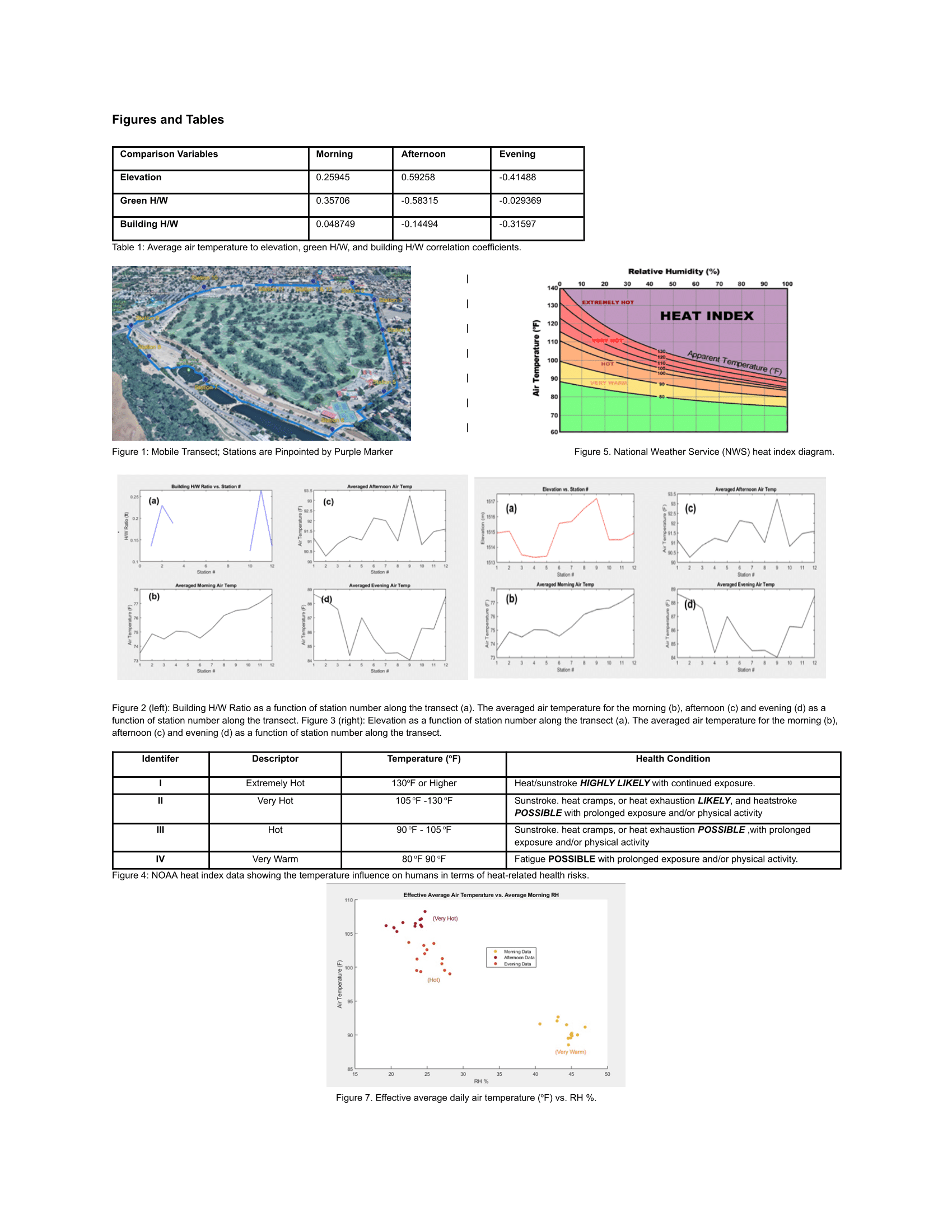
 - Indicates paper has been withdrawn from meeting
 - Indicates an Award Winner