
MCSs can be studied through high-resolution atmospheric modeling or by analyzing remote sensing imagery, which captures essential MCS characteristics such as cloud-top temperature gradients and distinctive spatial temperature patterns. However, current research efforts using remote sensing data are hindered by two main challenges: the scarcity of large-scale, annotated satellite databases of MCSs and the lack of sophisticated automated tools for their identification and tracking. To address these issues, this study introduces an integrated approach combining data annotation, dataset development, and deep learning techniques for improved MCS detection.
First, we present GeoAnnotateAssisted, a tool designed for the rapid and intuitive visual identification of MCSs in satellite imagery. This tool not only facilitates manual labeling but also incorporates AI-generated label suggestions, significantly improving the efficiency of dataset creation. Using this tool, we developed the Dataset of Mesoscale Convective Systems over the European Territory of Russia (DaMesCoS-ETR), a curated collection of annotated MCS occurrences based on Meteosat MSG/SEVIRI satellite data. This dataset serves as a valuable resource for training and validating machine learning models for MCS detection.
Additionally, we introduce MesCoSNet, a deep convolutional neural network for MCS identification, built upon the RetinaNet architecture. This model is specifically trained to detect MCSs in Meteosat MSG/SEVIRI imagery, achieving high performance with a mean average precision (mAP) of 0.75, a true positive rate (TPR) of 0.61, and a well-calibrated detection uncertainty (false alarm ratio, FAR = 0.36). By optimizing hyperparameters and leveraging the DaMesCoS-ETR dataset, MesCoSNet enhances the accuracy and reliability of automated MCS identification.
Beyond MCS detection, we demonstrate the broader applications of the tools and dataset developed in this study. One key application is the generation of a climatology of axisymmetric MCSs over the European territory of Russia, covering the summer seasons (May to September) from 2014 to 2020. This analysis, conducted using MesCoSNet, provides new insights into MCS occurrence patterns and their regional distribution.
By integrating advanced annotation tools, a high-quality dataset, and a robust deep learning model, this study contributes to overcoming existing challenges in MCS research. The automated identification of MCSs through MesCoSNet opens up new opportunities for studying previously unexplored aspects of MCS behavior and their role in atmospheric dynamics. This work paves the way for improved forecasting models, enabling more accurate risk assessment and mitigation strategies for severe weather events.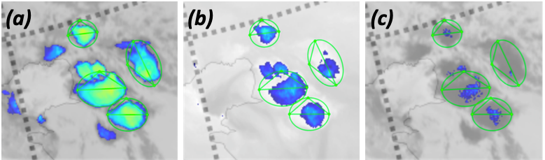
 - Indicates paper has been withdrawn from meeting
 - Indicates an Award Winner