
Wednesday, 15 January 2025: 2:15 PM
202 (New Orleans Ernest N. Morial Convention Center)
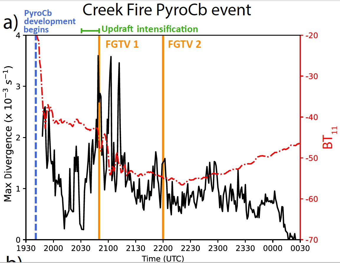
Convective dynamics in a supercell thunderstorm, a volcanic eruption, and two
pyrocumulonimbus (pyroCb) events are compared by computing cloud‐top divergence (CTD) with an optical
flow technique called Deepflow. Visible 0.64‐μm imagery sequences from Geostationary Operational
Environmental Satellites (GOES)‐R series Advanced Baseline Imager (ABI) are used as input into the optical
flow algorithm. CTD is computed after post‐processing of the retrieved motions. Analysis is performed on
specific image times, as well as the full time series of each case. Multiple CTD‐based parameters, such as the
maximum and the two‐dimensional area exceeding a specified CTD threshold, are examined along with the
optical flow‐retrieved wind speed. CTD is shown to accurately and quantitatively represent the behavior and
magnitude of different deep convective phenomena, including distinguishing between convective pulses within
each individual event. CTD captures updraft intensification as well as differences in convective activity between
two pyroCb events and individual updraft pulses occurring within a single pyroCb event. Finally, the
characteristics of high‐altitude smoke plumes injected by two separate pyroCb pulses are linked to CTD using
ultraviolet aerosol index and satellite imagery. Optical flow‐derived parameters can therefore be applied to
individual pyroCbs in real‐time, with potential to characterize pyroCb smoke source inputs for downstream
smoke modeling applications and to facilitate future tools supporting air quality modeling and firefighting
efforts.
pyrocumulonimbus (pyroCb) events are compared by computing cloud‐top divergence (CTD) with an optical
flow technique called Deepflow. Visible 0.64‐μm imagery sequences from Geostationary Operational
Environmental Satellites (GOES)‐R series Advanced Baseline Imager (ABI) are used as input into the optical
flow algorithm. CTD is computed after post‐processing of the retrieved motions. Analysis is performed on
specific image times, as well as the full time series of each case. Multiple CTD‐based parameters, such as the
maximum and the two‐dimensional area exceeding a specified CTD threshold, are examined along with the
optical flow‐retrieved wind speed. CTD is shown to accurately and quantitatively represent the behavior and
magnitude of different deep convective phenomena, including distinguishing between convective pulses within
each individual event. CTD captures updraft intensification as well as differences in convective activity between
two pyroCb events and individual updraft pulses occurring within a single pyroCb event. Finally, the
characteristics of high‐altitude smoke plumes injected by two separate pyroCb pulses are linked to CTD using
ultraviolet aerosol index and satellite imagery. Optical flow‐derived parameters can therefore be applied to
individual pyroCbs in real‐time, with potential to characterize pyroCb smoke source inputs for downstream
smoke modeling applications and to facilitate future tools supporting air quality modeling and firefighting
efforts.
 - Indicates paper has been withdrawn from meeting
 - Indicates an Award Winner